found.husk.org
images.
tagged map.
page 4 of 13 with 305 images.
connections
diagram
flow
flowchart
graph
lines
map
network
nodes
plan
process
relationships
visualization
workflow
More Paper Sizes | Flickr - Photo Sharing!
architecture
blueprint
building
design
first
floor
floorplan
map
plan
vintage
PSA 06-01305 | Flickr - Photo Sharing!
aerial
city
cityscape
grid
london
map
network
overhead
street
urban
SIMON ELVINS
building
city
design
direction
guide
interior
map
signs
urban
wayfinding
IdN™ Creators® — Marque (Glasgow, UK)
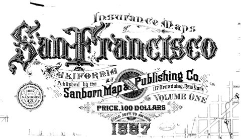
1887
san francisco
california
company
insurance
map
price
publishing
sanborn
volume one
sf-sanborn-lettering-1887.jpg (1526×880)
intersection
city
depot
map
network
plan
railroad
railway
street
tracks
Sheet 006
germany
map
munich
city
directions
isar
plan
street
travel
urban
Munich 1972 - Official Guide | Flickr - Photo Sharing!
geographic
finland
helsinki
city
detailed
map
plan
roads
streets
urban
underground masterplan | Flickr - Photo Sharing!
england
i-spy
london
guide
map
retro
sights
tourism
travel
vintage
I-Spy Map | Flickr - Photo Sharing!
america
usa
country
data
geography
map
nation
points
states
united
U.S. City Labels, z4-z7 | Flickr - Photo Sharing!
1942
san francisco
city
downtown
map
one-way
parking
plan
streets
traffic
Proposed One-Way Streets and No Parking Recommendations, Central Business District for Immediate Adoption (1942) | Flickr - Photo Sharing!
architecture
blueprint
building
city
design
grid
layout
map
plan
structure
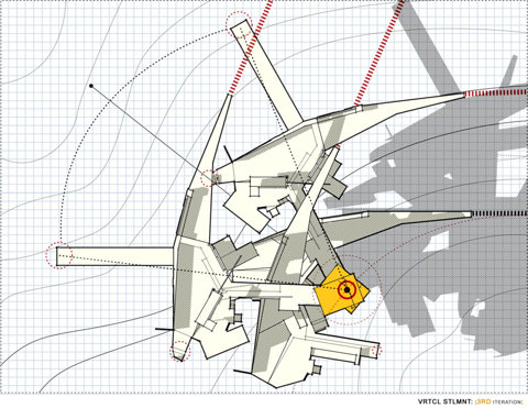
Vigilism Sketchpad, vertical semi-iterative:
british
england
guide
isles
location
map
tourism
travel
uk
wales
You are here | Flickr - Photo Sharing!
europe
black
continent
forest
green
land
landmass
map
red
satellite
Europe In Place Names – Source: Geonames Database, January 2011
bay
blue
city
coast
green
land
map
rural
urban
water
Original BART proposal | Flickr - Photo Sharing!
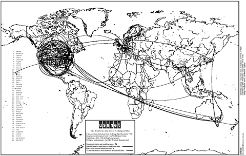
1996
communication
connectivity
global
internet
map
network
usenet
usenet-map
world
world_usenet_1986_large.gif (GIF Image, 1493x946 pixels)
usa
circles
clustered
connected
dots
filled
map
network
outline
states
indiemaps.com/blog » E00Parser, an ActionScript 3 parser for the Arc/Info Export topological GIS format
city
direction
guide
hand
location
map
pointer
street
travel
walk
Flickr Photo Download: WalkRide Newcastle Gateshead Map
city
infrastructure
map
navigation
network
river
roads
streets
transportation
urban
oneYearLND09-10_101115-large.jpg (2362×1662)
chart
coastline
geography
island
map
nautical
navigation
ocean
scotland
sea
Local Magnetic Anomalies | Flickr - Photo Sharing!
city
grid
infrastructure
map
network
plan
roads
streets
transportation
urban
Personal geography of 2010 | Flickr - Photo Sharing!
art
bay
bridge
city
colorful
map
mosaic
oakland
san francisco
tile
tiley maps! | Flickr - Photo Sharing!
city
diagram
grid
guide
layout
map
navigation
plan
street
urban
2010 End-of-the-Year Card
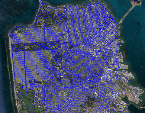
san francisco
aerial
blue
city
grid
map
network
roads
street
urban
Where I've been | Flickr - Photo Sharing!