found.husk.org
images.
tagged usa.
17 images.
basketball
court
game
kid
map
outdoor
park
play
playground
usa
YannArthusBertrand2.org - Fond d écran gratuit à télécharger || Download free wallpaper - Jeune écolier de l’école élémentaire Torrance Cornestone à Los Angeles, Californie, États-Unis (33°49’ N - 118°20’ O).
usa
black
border
continent
country
map
outline
rivers
states
white
Bodies of water most closely connected to US national boundaries | Flickr - Photo Sharing!
apollo
nasa
saturn v
usa
flight
history
launches
missions
rockets
space
A montage of all Saturn V launches, 1967–1973. | Flickr - Photo Sharing!
1940
us
usa
census
cities
demography
geography
map
population
states
Population Graphic | Flickr - Photo Sharing!
america
usa
united states
abstract
colorful
country
geometric
map
mosaic
states
finallowres | Flickr - Photo Sharing!
america
usa
country
data
geography
map
nation
points
states
united
U.S. City Labels, z4-z7 | Flickr - Photo Sharing!
usa
circles
clustered
connected
dots
filled
map
network
outline
states
indiemaps.com/blog » E00Parser, an ActionScript 3 parser for the Arc/Info Export topological GIS format
america
greyhound
usa
bus
discover
journey
lines
map
route
travel
Gallery: Mapping out the American dream | Books | guardian.co.uk
usa
america
american
map
motto
quotes
state
states
united
words
Gallery: Mapping out the American dream | Books | guardian.co.uk
usa
charts
coast
map
nautical
nautical chart
navigation
ocean
sailing
sea
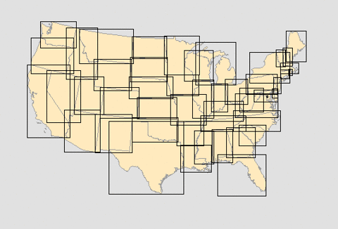
Unlocking the Mysteries of the Bounding Box
america
usa
doodle
hand-drawn
highway
journey
map
road trip
route
travel
russell davies: back in the day
astronaut
launch
mission
nasa
platform
rocket
shuttle
space
usa
vehicle
First of the last Space Shuttle launches - The Big Picture - Boston.com
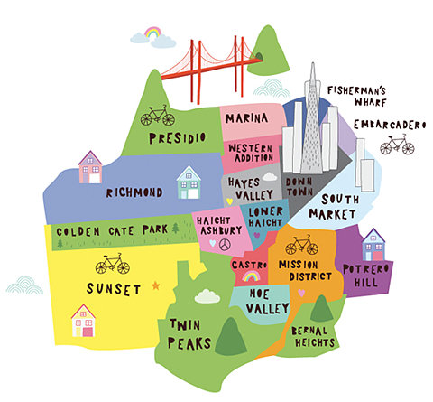
bicycle
california
city
districts
guide
map
neighborhoods
san francisco
travel
usa
city
districts
guide
locations
map
neighborhoods
tourism
travel
Chloe Fleury//Illustration
launch
launchpad
mission
nasa
pad
rocket
shuttle
space
usa
vehicle
BBC News | Enlarged Image
usa
united states
black
density
dots
gray
grid
map
population
white
all streets | ben fry
america
usa
black
borders
continent
country
map
nation
states
united
Flickr Photo Download: Dorfsman & CBS
usa
art
country
craft
license
map
plates
rustic
states
vintage
Amazing License Plate Map - EchoPic


