found.husk.org
images.
tagged country.
12 images.
usa
black
border
continent
country
map
outline
rivers
states
white
Bodies of water most closely connected to US national boundaries | Flickr - Photo Sharing!
america
usa
united states
abstract
colorful
country
geometric
map
mosaic
states
finallowres | Flickr - Photo Sharing!
america
usa
country
data
geography
map
nation
points
states
united
U.S. City Labels, z4-z7 | Flickr - Photo Sharing!
england
scotland
uk
wales
country
density
dots
green
map
population
Geonames Maps « optional.is/required
border
coast
country
england
fantasy
green
ireland
map
north
sea
334 - The Atlas of True Names « Strange Maps
england
uk
cities
country
density
geography
location
map
population
size
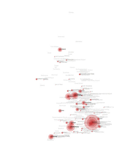
Flickr Photo Download: Top placenames from BBC search on July 9th
borders
cartographic
coastline
country
geographic
island
landmass
map
outline
terrain
Flickr Photo Download: SHAPEZ (2009-03-24)
chart
country
economy
graph
infographic
land
map
pie
pizza
world
The Economist: Crop | Ads of the World: Creative Advertising Archive & Community
city
connections
country
estuary
gateway
map
parkland
river
thames
urban
cabe-700.gif (GIF Image, 1050x634 pixels)
america
usa
black
borders
continent
country
map
nation
states
united
Flickr Photo Download: Dorfsman & CBS
.com
country
country codes
domain
domain names
global
internet
web
world map
Country Codes of the World (Byte Level Research)
usa
art
country
craft
license
map
plates
rustic
states
vintage
Amazing License Plate Map - EchoPic


