found.husk.org
images.
tagged map.
page 3 of 13 with 305 images.
bay
california
detail
historical
map
old
peninsula
san francisco
topographic
vintage
Stages of development of the San Bruno Turnpike/Bayshore Highway (2002) | Flickr - Photo Sharing!
city
san francisco
blocks
density
grid
layout
map
population
urban
San Francisco population density by block (2006) | Flickr - Photo Sharing!
city
dots
geometric
grid
lines
map
network
points
structure
urban
Untitled | Flickr - Photo Sharing!
london
city
city map
england
grid
location
map
markers
pins
streets
Untitled | Flickr - Photo Sharing!
celestial
complex
diagram
graph
illustration
map
orbit
science
space
technical
Cosmo Graphic: Orbit | Flickr - Photo Sharing!
abstract
connections
data
graph
lines
map
network
nodes
visualization
web
The true continents of the world (geo-accurate edition) | Flickr - Photo Sharing!
europe
city
dark
earth
globe
lights
map
night
satellite
stars
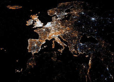
European detail map of Flickr and Twitter locations | Flickr - Photo Sharing!
city
earth
globe
lights
map
night
planet
satellite
urban
world
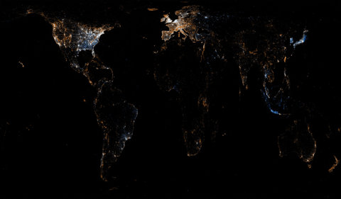
World map of Flickr and Twitter locations | Flickr - Photo Sharing!
1850
san francisco
burned
city
destruction
devastation
disaster
earthquake
fire
map
Geopolitical – Map – American – San Francisco Earthquake Burned Areas | Vintage Printable at Swivelchair Media – Beta
chart
coast
coastline
depth
map
nautical
ocean
sea
water
From the map | Flickr - Photo Sharing!
grid
abstract
city
geometric
lines
map
network
pattern
texture
urban
[this is aaronland] Things I Have Written Elsewhere #1305615600
city
density
development
grid
infrastructure
map
network
population
urban
urban sprawl
See something or say something | Flickr - Photo Sharing!
abstract
data
geometric
graph
grid
map
network
polygon
tessellation
visualization
Code: Flickr Developer Blog » The Only Question Left Is
1951
london
south bank
thames
exhibition
festival
festival hall
guide
map
riverside
Map of South Bank Exhibition | Flickr - Photo Sharing!
us
blue
highways
interstate
map
network
roads
route
transportation
travel
usa | Flickr - Photo Sharing!
america
usa
united states
abstract
colorful
country
geometric
map
mosaic
states
finallowres | Flickr - Photo Sharing!
2005
conservative
election
labour
london
map
parties
politics
tube
uk
PoliticsTubeMap1 | Flickr - Photo Sharing!
massachusetts
worcester
city
geography
map
pieces
puzzle
ripped
state
torn
mockup: massachusetts townships | Flickr - Photo Sharing!
abstract
city
design
lines
map
network
string art
subway
transportation
urban
String map 1 | Flickr - Photo Sharing!
city
cluster
data
dense
distribution
location
map
population
traffic
urban
photos near the studio (2011) | Flickr - Photo Sharing!
map
uk
abstract
black
black triangles
geographic
map
pattern
triangles
white
map
uk
abstract
black
black triangles
geographic
map
pattern
triangles
white
deviate from the traditional analytic and process role | Flickr - Photo Sharing!
london
map
network
public
subway
transit
transport
transportation
tube
underground
Tube Journey : Michael Jack, Architect
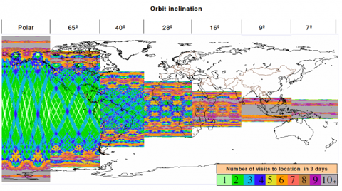
coverage
days
earth
inclination
location
map
orbit
satellite
swath
visits
Secret Space Plane Can’t Hide From Amateur Sleuths | Danger Room | Wired.com
city
london
map
metro
network
rail
subway
transport
tube
underground
Climate Changed Tube Map : Oliver Bishop-Young


![[this is aaronland] Things I Have Written Elsewhere #1305615600](https://storage.googleapis.com/huskorg-images/ffffound/91c950e759e839a1a2bfaf7f0b4add15e5c5b1b6.jpg)