found.husk.org
images.
tagged city.
page 2 of 15 with 341 images.
city
dots
geometric
grid
lines
map
network
points
structure
urban
Untitled | Flickr - Photo Sharing!
london
city
city map
england
grid
location
map
markers
pins
streets
Untitled | Flickr - Photo Sharing!
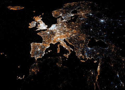
europe
city
dark
earth
globe
lights
map
night
satellite
stars
European detail map of Flickr and Twitter locations | Flickr - Photo Sharing!
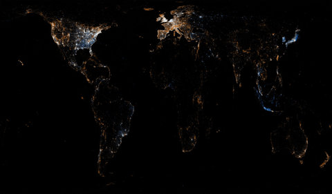
city
earth
globe
lights
map
night
planet
satellite
urban
world
World map of Flickr and Twitter locations | Flickr - Photo Sharing!
1850
san francisco
burned
city
destruction
devastation
disaster
earthquake
fire
map
Geopolitical – Map – American – San Francisco Earthquake Burned Areas | Vintage Printable at Swivelchair Media – Beta
1930s
aerial
airship
architecture
building
city
modern
skyscraper
urban
vintage
angel flores jr - Not Just a Perch for King Kong The mooring mast atop the Empire State Building was said to be for dirigibles. But it also made the building taller than its rival for height, the Chrysler Building.
airship
buildings
city
dark
lights
new york
night
nyc
skyline
skyscraper
angel flores jr - Not Just a Perch for King Kong The mooring mast atop the Empire State Building was said to be for dirigibles. But it also made the building taller than its rival for height, the Chrysler Building.
grid
abstract
city
geometric
lines
map
network
pattern
texture
urban
[this is aaronland] Things I Have Written Elsewhere #1305615600
architecture
building
city
downtown
drawing
facade
lines
sketch
skyscraper
urban
municipal plaza building | Flickr - Photo Sharing!
city
density
development
grid
infrastructure
map
network
population
urban
urban sprawl
See something or say something | Flickr - Photo Sharing!
earth
city
darkness
globe
lights
night
planet
sky
space
stars
United Kingdom and Ireland as seen from ISS | Flickr - Photo Sharing!
3d
abstract
architecture
building
city
cityscape
design
model
scan
wireframe
Subverting the LiDAR Landscape - Latest - ScanLAB Projects
london
boats
bridge
buildings
city
cityscape
panorama
river
sky
water
Experiment | Flickr - Photo Sharing!
street
london
st. paul's
architecture
cathedral
city
drawing
illustration
plan
view
St Paul's from the river bank - illustration by Gordon Cullen, 1949 | Flickr - Photo Sharing!
architecture
buildings
city
construction
design
landscape
model
modern
plan
urban
Postcard from Berlin, capital of the German Democratic Republic (approx. 1968) | Flickr - Photo Sharing!
massachusetts
worcester
city
geography
map
pieces
puzzle
ripped
state
torn
mockup: massachusetts townships | Flickr - Photo Sharing!
london
architecture
building
city
cityscape
glass
modern
skyscraper
triangle
urban
London I love you and I am still trying to figure you out | Flickr - Photo Sharing!
abstract
city
design
lines
map
network
string art
subway
transportation
urban
String map 1 | Flickr - Photo Sharing!
city
cluster
data
dense
distribution
location
map
population
traffic
urban
photos near the studio (2011) | Flickr - Photo Sharing!
city
london
map
metro
network
rail
subway
transport
tube
underground
Climate Changed Tube Map : Oliver Bishop-Young
aerial
city
cityscape
grid
london
map
network
overhead
street
urban
SIMON ELVINS
building
city
design
direction
guide
interior
map
signs
urban
wayfinding
IdN™ Creators® — Marque (Glasgow, UK)
intersection
city
depot
map
network
plan
railroad
railway
street
tracks
Sheet 006
germany
map
munich
city
directions
isar
plan
street
travel
urban
Munich 1972 - Official Guide | Flickr - Photo Sharing!


![[this is aaronland] Things I Have Written Elsewhere #1305615600](https://storage.googleapis.com/huskorg-images/ffffound/91c950e759e839a1a2bfaf7f0b4add15e5c5b1b6.jpg)


