found.husk.org
images.
tagged political.
8 images.
buckminster
design
dymaxion
fuller
geographer
geography
globe
map
political
world
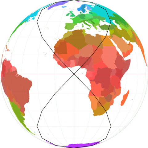
2) Critique of Fuller's Dymaxion Map compared to B.J.S. Cahill's Octahedral
europe
atlas
blue
borders
continent
continents
countries
dots
geographical
geography
globe
location
map
ocean
political
regions
travel
world
lines of law and commerce | Flickr - Photo Sharing!
borders
continents
countries
earth
geography
globe
international
map
political
world
File:Lines of equal latitude and longitude FROM (World borders parallel.png).PNG - Wikipedia, the free encyclopedia
administrative
arctic
canada
map
north
nunavut
political
provinces
regions
territory
shipping | Flickr - Photo Sharing!
1960s
book
cover
election
labor
labour
pamphlet
political
propaganda
why
Stylish Penguin and Pelican Book Covers | Abduzeedo | Graphic Design Inspiration and Photoshop Tutorials
britain
political
uk
authoritarianism
chart
demographics
graph
liberalism
political science
spectrum
New Prospect poll: The rise of Britain’s liberal “twittering classes” « Prospect Magazine
soviet
art
communist
political
poster
propaganda
russia
soldiers
uniform
vintage
weetstraw.com - Russian Book Jackets
abstract
collage
distressed
political
president
protest
sign
vintage
vote
woman
Ian Carr :portfolio: illustrations


.PNG)